

HOUSING AND ACCESSIBILITY
Ana Ortiz e Iñigo Azcárate
This project aims to address the growing challenge of housing affordability in Gipuzkoa through a data-driven and evidence-based approach. Housing is a fundamental pillar of territorial development, shaping not only living conditions but also access to employment opportunities, education, public services, and overall quality of life.
The project combines complementary datasets to analyze the housing crisis from multiple perspectives. It examines market dynamics through housing prices, while incorporating administrative and demogaphic data to capture broader structural factors. These datasets are further integrated with accessibility and mobility indicators, allowing for an assessment of how access to jobs, services, and transport networks shapes housing demand and affordability across the territory.
By linking housing and accessibility dimensions, the project provides a more comprehensive understanding of affordability challenges and supports evidence-based planning and policy development in Gipuzkoa.
Data sources
CADASTRE (Provincial Tax Office of Gipuzkoa)
Official database with the cadastral value of 331,698 urban dwellings across the 88 municipalities of Gipuzkoa, obtained from fixed-width files cross-referenced through a five-field composite key (municipality, cadastral reference, property record, control digit, and unit).
IDEALISTA (Housing Market)
1,191 active for-sale listings as of April 2026, extracted through Idealista's official API, cleaned of duplicates and rural/dispersed housing, distributed across 59 municipalities in the province.
TERRITORIAL ACCESIBILITY (time_data)
Travel-time matrix from 58,768 cadastral parcels to 80 essential services (healthcare, education, retail, public transport, leisure) across four transport modes —walking, cycling, driving, and public transport— developed in previous CSL@Gipuzkoa research.
Methodology
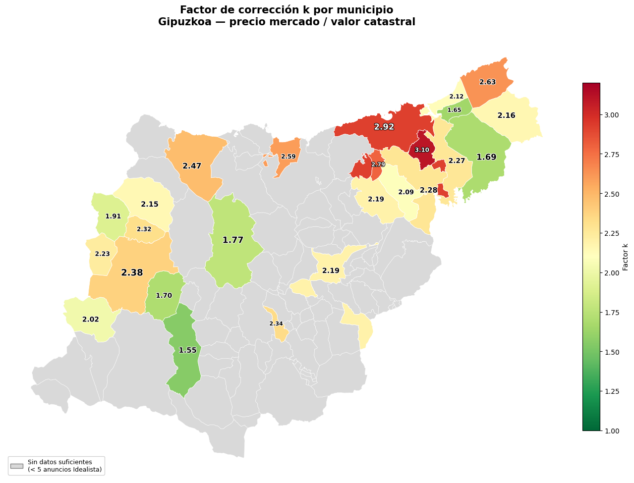
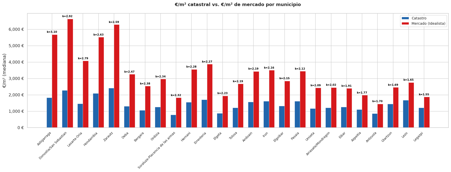
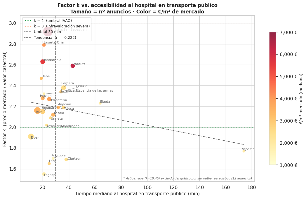
The three data sources were integrated at municipal level through a sequential merge: each source was first aggregated by computing the median of its main variable per municipality (cadastral price, market price, travel time), and then cross-referenced using the municipality code as a common key. This integration enabled the calculation of the cadastral correction factor k (market price / cadastral value) for the 25 municipalities with sufficient statistical representativeness, as well as two accessibility indices —everyday and regional— derived from travel times to essential services. These indicators were further cross-referenced with demographic and income data from the Spanish National Statistics Institute (INE) to analyze the relationship between accessibility, cadastral undervaluation, and housing prices.
Results
👉Link to the full report:
Interactive dashborad: https://anaortizperez.github.io/dashboard-guip-zca/